搜索结果: 1-14 共查到“信息与通信工程 visualization”相关记录14条 . 查询时间(0.078 秒)

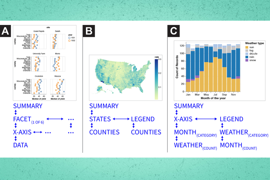
Making data visualization more accessible for blind and low-vision individuals(图)
盲人 低视力人士 数据可视化
2023/6/20
In the previous years, research in environmental sciences has become more and more important as we are faced with increasing problems concerning climate change, water scarcity, pollution of the enviro...
Red Relief Image Map: New Visualization Method for Three Dimensional Data
LIDAR Application Visualization DEM/DTM Graphics Representation
2015/12/3
The vast increase of the volume of three dimensional topographic data acquired by Airborne LIDAR extends the possibility of the visualization method. The maximum laser pulse frequency of modern LIDAR ...
Communication and Visualization of 3D Urban Spatial Data According to User Requirements: Case Study of Geneva
urban data three-dimensional user requirements modelling visualization LIDAR
2015/12/2
In 2005, the main commission of the technical services of the city of Geneva launched a study to evaluate which users would potentially be interested to integrate the third dimension in the available ...
Integration of LIDAR and Airborne Imagery for Realistic Visualization of 3D Urban Environments
LiDAR Georeferencing True Orthophoto Generation 3D Visualization Urban Environments
2015/12/2
In its report "State of the World Cities 2006/07", the United Nations states that the number of urban area inhabitants is expected to rise to almost 5 billion by 2030, constituting roughly 62% of the ...
Data Management Based on Geocoding Index And Adaptive Visualization for Airborne LIDAR
Laser scanning (LiDAR) Data management Aerial Survey Coding Process modeling
2015/11/20
With more surveying practice and deeper application, data post-process for airborne LiDAR system has been extracted lots of attention in data accuracy, post-process, fusion, modeling, automation and v...
VIRTUAL RESEARCH ENVIRONMENT FOR THE MANAGEMENT AND THE VISUALIZATION OF COMPLEX ARCHAEOLOGICAL SITES
Information Systems Data Management Interactive Visualizations Internet Archaeology
2015/10/8
Virtual Research Environments are tools and technologies to enhance and support research. These online environments are dedicated to
support collaboration whether in the management of a research acti...
NEAR REALISTIC AND THREE DIMENSIONAL VISUALIZATION OF TERRAIN USING LIDAR DATA
Immersive Visualization Geovisualization LiDAR
2015/9/28
Visualization in scientific computing has been a thrust area in the field of computer science since the last century. This has triggered
the development of technology in terms of memory, ...
A DEPENDENCY MATRIX TO ASSIST IN THE VISUALIZATION OF GEOSPATIAL IMAGE QUALITY
Visualization Quality Imagery Databases Decision Support
2015/8/31
Professionals of various backgrounds have recognized the value that the use of geospatial imagery can add to their analysis. They
take advantage of the widespread availability of data in vast image ...
INTEGRATED USE OF TM IMAGE, DTM AND 3D VISUALIZATION IN GROUNDWATER STUDIES ON KARSTIFIED MARBLES
Geology Resources Integration Interpretation
2015/7/29
The purpose of this study was the evaluation of integrated use of landsat TM imagery, Digital Terrain Model (DTM) and 3D
visualization for groundwater studies on karstified marbles. It was used a mu...
Implementation of Progressive Transmission Algorithms for Vector Map Data in Web-based Visualization
algorithms visualization hierarchy web based
2015/7/6
This paper investigates the benefits of progressive transmission of vector data, through designing and developing a hierarchical data
model to compress vector data for progressive transmission over t...
Photogrammetric data, whether it refers to terrain or to close-range images, are typically massive in size. This results in a dataset that is often too large to handle and prohibits any form of real-t...
HEURISTICAL FEATURE EXTRACTION FROM LIDAR DATA AND THEIR VISUALIZATION
LIDAR segmentation feature extraction visualization
2014/6/5
Extraction of landscape features from LiDAR data has been studied widely in the past few years. These feature extraction methodologies have been focussed on certain types of features only, namely the ...
A FRAMEWORK FOR ONLINE SPATIO-TEMPORAL DATA VISUALIZATION BASED ON HTML5
Spatio-temporal data Web based visualization HTML5 WebSocket Canvas
2014/4/25
Web is entering a new phase – HTML5. New features of HTML5 should be studied for online spatio-temporal data visualization. In the proposed framework, spatio-temporal data is stored in the data server...


